
Big Gee in Action


| Album: journal:20110803 | ||||||||||
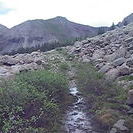
After a short uphill the stock driveway led me to the Cross Mountain Trail and up to Lizard Head. The clouds formed early over Navajo Basin and I was happy I bypassed those summits. I wasn't much better off hiking up to the Cross Mtn - Lizard Head saddle however. The pass tops out at 12,000 feet and the clouds soon blew over to above me and Lizard Head. I was over and well into descending Bilk Basin before any rain and thunder arrived at least. The basin is another example of the map not showing the trail correctly. It's basically right but the line on the map is not where the trail really is so I am very glad that I wasn't using these to navigate through the snow on the CT. This means I'm also not really sure what my actual mileage is. Under a tree avoiding passing showers I came to the realization that it is August 3 and I have only 3 weeks before classes start. I always figured that I could hike close, start classes, and then finish up with some long weekend trips in September but I don't think that will be possible after all. I have some challenging terrain coming up and I think that I'll have too many miles left to finish up as 3-4 day trips before the snow returns. I will sadly need to spend time doing homework. I'll keep hiking because that is what I'm here to do but in Telluride I'll have to think about good places to get off the trail. Bummer. Bilk Basin ended upwith an awesome waterfall, cascades, and rapids. Spectacular. Then there were some cool mining remains that I checked out. From that point the trail was very overgrown and I missed my turn (or it no longer exists) to Sunshine Mesa TH. Good thing that a couple miles further was a junction with the Wilson Mesa trail. I took that to the right and got back on track though that misstep cost me 3 extra miles and 500+ more vertical feet. At the Sunshine Mesa TH I hiked about a half mile down the road until I found some mediocre camping. |
||||||||||
| Available Images: | ||||||||||
 |
 |
 |
 |
|||||||
| imgp5180 | imgp5181 | imgp5182 | imgp5183 | |||||||
 |
 |
 |
 |
|||||||
| imgp5185 | imgp5187 | imgp5189 | imgp5190 | |||||||
 |
 |
 |
 |
|||||||
| imgp5191 | imgp5192 | imgp5193 | imgp5194 | |||||||
 |
 |
 |
 |
|||||||
| imgp5195 | imgp5196 | imgp5197 | imgp5198 | |||||||
 |
 |
 |
 |
|||||||
| imgp5199 | imgp5200 | imgp5201 | imgp5202 | |||||||
 |
 |
 |
 |
|||||||
| imgp5203 | imgp5204 | imgp5205 | imgp5206 | |||||||
 |
 |
 |
 |
|||||||
| imgp5207 | imgp5208 | imgp5209 | imgp5210 | |||||||
 |
 |
 |
 |
|||||||
| imgp5211 | imgp5212 | imgp5215 | imgp5218 | |||||||
 |
 |
 |
 |
|||||||
| imgp5219 | imgp5221 | imgp5222 | imgp5223 | |||||||
 |
 |
 |
 |
|||||||
| imgp5224 | imgp5225 | imgp5226 | imgp5227 | |||||||
 |
 |
 |
 |
|||||||
| imgp5228 | imgp5230 | imgp5231 | imgp5233 | |||||||
 |
 |
 |
||||||||
| imgp5234 | imgp5235 | imgp5236 | ||||||||